NEWS: The AvioScout-Mission system has been granted ETSO authorisation by EASA.
|
Affordable mission-system for helicopters
Optimized for Police and Medical Rescue (HEMS) Operations
Ready for your mission and your budget
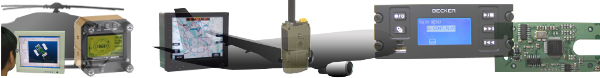
All you need in mission system in a compact housing
- Dim: 160 * 136 * 90mm
- Weight: 1.5kg
- Sun-light readable display, 6.5", 640*480 pix, 700 nits
- Integrated GPS+GLONASS receiver
- Integrated Iridium Data Modem
- Certified to ETSO C113, Software DO-178C level D
Find out more:
|
Key Features
- Easy to use
- Full situational awareness for pilot and mission control center
- Compact system standard 160mm width
- Simple to install
- ETSO certified (C113, in preparation)
- Affordable for your budget
- Shorter reaction time
- Error and workload reduction
- Better vehicle utilization by avoiding empty flights
|
Basic Software Functions
- Display of pixel maps
- Display of vector maps, with streets and house numbers
- Display in North-up or Heading-up mode. Change with the press of a button
- Simple zoom with rotary knob, with automatic change of map.
- In Heading-up mode the present position is shown in the lower third of the display, so more area ahead is visualized.
- Depiction of speed vector. Its length shows the range for the next two minutes.
- Recording of flight path (trace). It can be saved and later recalled for display or exported for display and printed for documentation.
- Display of track, ground speed, bearing ETE and ETA and distance to go.
|
Overlays
All overlays can easily be switched on and off.
- ATC (air traffic control) overlay. Showing control zones, etc.
- Airports
- Trace (flight path)
- Terrain height. Terrain higher than the current altitude is colored on the map – a simple HTAWS.
- FLARM, ADS-B or TCAS targets are displayed on the map if appropriate equipment is installed
- Obstacle overlay. The operator can create and maintain his own obstacle overlay.
EOS/FLIR-Camera
If a EOS camera is installed and is able to supply the information
- Line of Sight. The point where the camera is looking at.
- Field of View. Area the camera is showing
- Camera picture. The screen can be switched between map and camera display. A small overlay can be shown besides the map.
Radio Direction Finder
If a radio-DF is installed, support for:
- Radio-Direction Finder
- Personal Locator Beacon Finder
|
Waypoints and Routes
- Address data base with towns, streets and house numbers
- Date base with airfields
- User defined POIs can be grouped in arbitrary as many lists as desired.
- Setting of waypoints using data base, coordinate input or simply be moving on the map.
- Home function, allows setting of a predefined waypoint with one button.
- NEAR function to select nearby landing places in case of emergency.
- MOB (Man Over Board) to store present position and recall them later to set a waypoint.
- The last 50 waypoints are automatically stored and can be easily recalled.
|